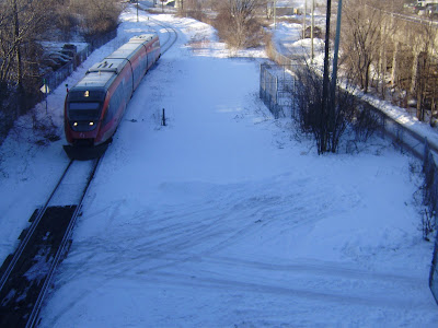
The underpass, a precast concrete "box", would be a few feet above the current track level, and set back from the track far enough to allow for a LRT station on the far side (southside) of Somerset, should one be installed. There are currently no plans for such a station, this is just good planning to allow the space for one.
The new tunnel would be both a cycling path and would permit pedestrians and users of any future LRT station to walk under Somerset and directly into any future City Centre redevelopment (recall the site is zoned for 5 or more towers, up to 22 floors or so)(not that any redevelopment is planned soon).
Photo two was taken from the Somerset Street level. It also shows how much space is available. A second rail track will be laid immediately to the right of the Otrain. There might also be "storage" tracks here for trains waiting to begin runs through the downtown and east. Provided a small berm and some landscaping is installed, it should be quite pleasant to cycle or walk along the corridor, given that the path will be set back from the moving trains and about one meter above the track level.
The City centre complex follows a curve as it goes north (the curve, of course, is defined by the curvature of the railway tracks that used to be under the elevated roadway and further west and north of the building). The cycling path would follow this curve and come out onto City Centre Avenue just north of Albert street, from which cyclists would have easy access to the downtown (via Albert) or to the River (via the Preston extension). Eventually, should Jim Watson fail to block the LRT project, the path could run north along the tracks to Bayview Station and the River and eventually the Gatineau Hills.
Personally, I would be perfectly happy with a stonedust path. It could even double as a service road to the tracks or warehouses, given the low volume of truck traffic that would entail. Eventually, as the LRT tracks are developed, I would expect the path to be paved and lit to be attractive to all types of users at all times of day and evening.


No comments:
Post a Comment